|
|
||||||||||||
|
||||||||||||
 |
||||||||||||
|
||||||||||||
|
||||||||||||
|
|
||||||||||||
 |
This tour is also available in a
pdf version. Click here
to open it. If you need to download Adobe Reader to open the pdf version, click on the logo.  |
|||||||||||
|
|
||||||||||||

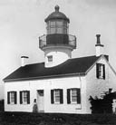 Photo courtesy The Pat Hathaway Collection |
Built in the 1850s and shining its beacon since February 1, 1855, this is the oldest continuously operating lighthouse on the West Coast. It marks the entrance to Monterey Bay and sits on the northernmost tip of the Peninsula. Although now powered by electricity, the building, lenses and prisms are all original. During the late 1800s, two of its lightkeepers were women. |
|
||
| Elizabeth Wayne remembers its foghorn (To a God Unknown, Chapter 21), William--the tragic watchman of the Bear Flag--laments here (Cannery Row, Chapter III), Suzy walks here (Sweet Thursday, Chapter 21) and Doc leaves his work in a mood of discontent and walks here, watching the light strike the ocean (Sweet Thursday, Chapter 3). | ||||
|
The Pacific Grove Museum of Natural
History maintains webpages with many
images of the Point Pinos Lighthouse. The Point Pinos Lighthouse is surrounded by the Pacific Grove Municipal Golf Links, also know as "the poor man's Pebble Beach." |
||||
|
This tour is also available in a pdf version. Click here to open it. |
||||
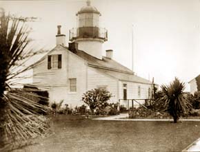 Point Pinos Lighthouse from the back, c. 1935. |
||||
|
After you back out of your parking space, continue right
on Asilomar Avenue to Ocean View Blvd. Turn left; Ocean View
turns into Sunset Drive. Drive just south of Point Pinos, at
the foot of the lighthouse and park your car on the ocean side
of the street. |
||||

|

|

|

|

|

|

|

|

|

|

|

|

|

|

|

|

|

|